If you manage to only do one hike during your visit to New Zealand, make sure it is the Tongariro Crossing on the North Island.
It is considered New Zealand’s best 1-day hike. In many circles, it is considered one of the best in the world.
Table of Contents
The Tongariro Alpine Crossing
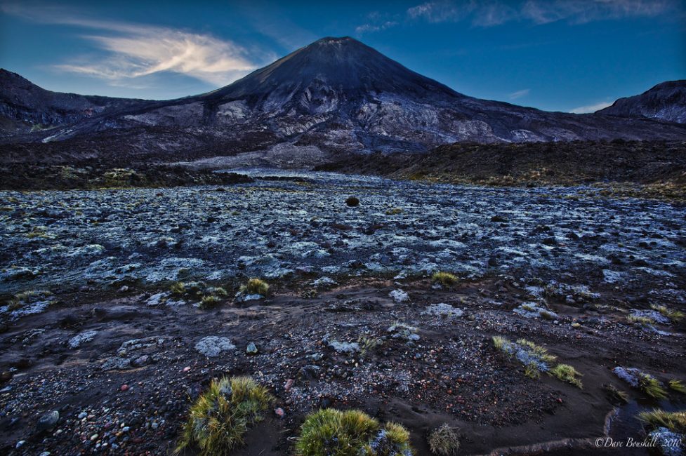
Located in Tongariro National Park, this 19.4km day hike takes you through the Mangatepopo Valley with magnificent views of Mount Ngauruhoe.
If the mountain looks familiar it is because Peter Jackson chose this location to be the dreaded Mount Doom in the Lord of the Rings.
What kind of hike is the Tongariro Crossing?
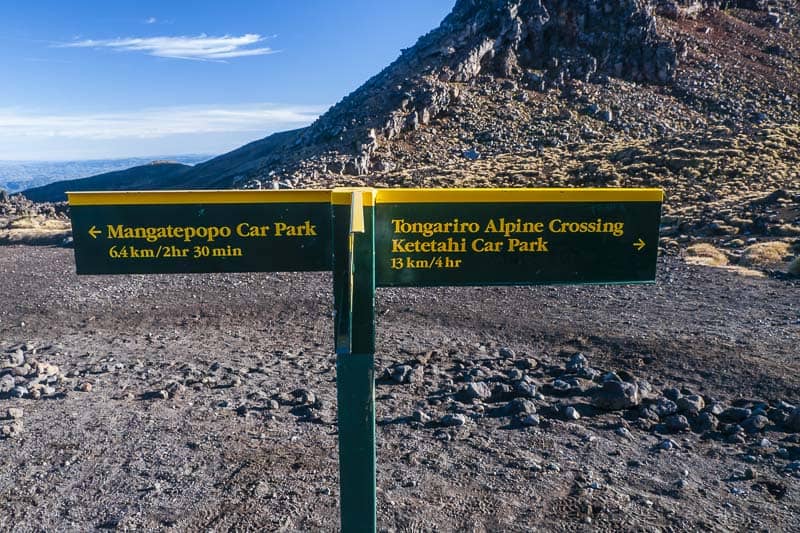
The Tongariro Crossing is a point-to-point hike and not a loop so we recommend that you book a shuttle to make things easier.There are quite a few shuttle services that will arrange this. We based ourselves in National Park Village and used Tongariro Crossing Shuttles.
They drop you off at one end and then pick you up when you finish. This is perfect since you will probably be pretty tired after six-plus hours of hiking.
It is important that you are prepared for any type of weather. Once you are out on the trail you do not want to be caught unprepared. We suggest checking the weather and volcanic activity on the Tongariro Crossing official website so that you can get the most up to date information before you head out on the trek.
Start of the Hike
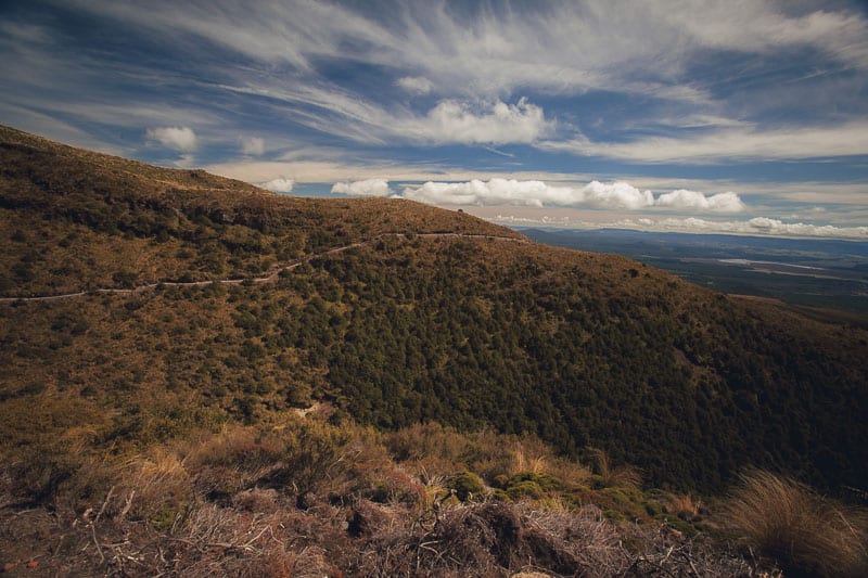
The day started early as we took a shuttle from National Park Village to the start of the hike at Mangatepopo car park. It can get really cold in the morning and we were bundled up to start things off. The beginning of the hike has you hiking through the beautiful alpine brush at a moderate incline, for about 50 minutes.
You can see how the landscape starts to change as you hike over volcanic soil and the first sight comes into focus. It is fairly easy hiking and gets you warmed up for what is to come.
Mount Doom
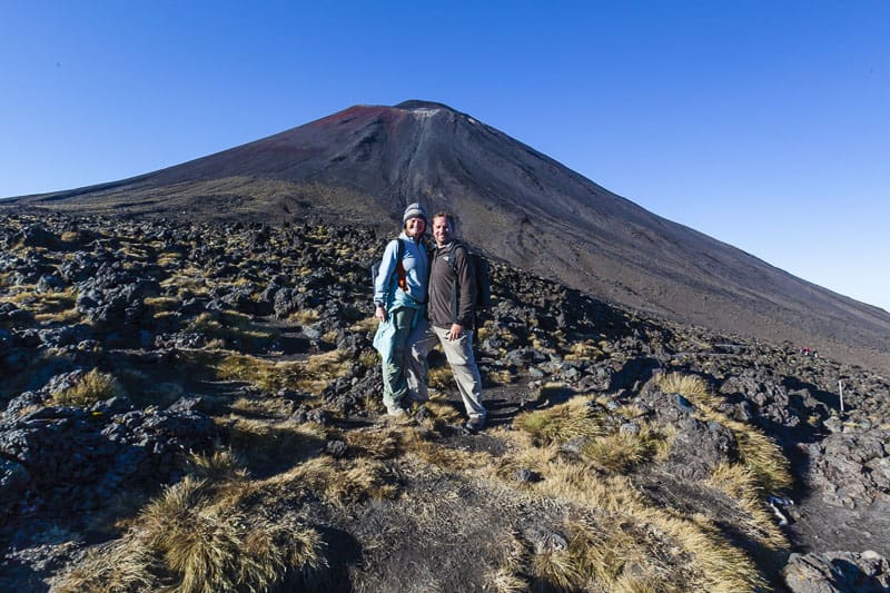
As you make your way out of the alpine vegetation you get your first glimpse of Mount Doom. It is impressive. But so is the incline that lies ahead.
This is where the hiking gets more difficult. The grade gets much steeper but the views also get better. We stopped here for a quick break and naturally took some photos of this iconic scene. Deb and I quickly understood why this is one of the most beautiful 1 day hikes in the world.
South Crater
As we make our way past Soda Springs on our way to the South Crater the views of the valley below are simply breathtaking. The track may be steep – You go from about 1200 metres above sea level to 1600 in a rather short time – but the views are worth it.
The track is very uneven here as you are walking over lava flows and volcanic rocks. There is a reason they call it the “Devil’s Staircase”. Make sure to take your time here, snap photos, and take in the view. It gives you a great sense of the beauty of the North Island. But the best views still lie ahead.
Red Crater
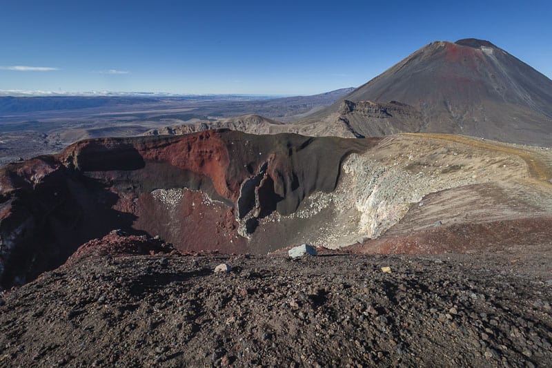
Walking along the South Crater is flat and pretty easy, but as you approach the Red Crater it gets quite windy and you end up scrambling a little to keep your footing. Take care here as it can get a little dangerous if you are not paying attention.
From the highest point on the Tongariro Alpine Crossing, we had incredible views of the emerald lakes, The Oturere Valley, Mt. Ruapehu, and what seems to be all of the North Island of New Zealand.
It will literally take your breath away. This is what you have been hiking for and the reward is well worth the effort.We took some time here to take it all in and appreciate the beauty of Mother Nature that seemed to surround us. Check out: 14 Cool and Fun Facts About New Zealand
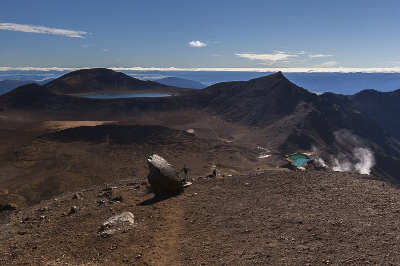
Descending to the Emerald Lakes

Now the fun begins. With the air thick with the smell of sulfur, we headed downhill towards the thermal pools at a relatively quick pace. The soil is loose and you can almost slide down it. It kind of reminded me of our scree descent from Mount Kilimanjaro in Africa.
Just be careful as there are steep drop-offs on each side and if you did fall you wouldn’t be stopping very fast.
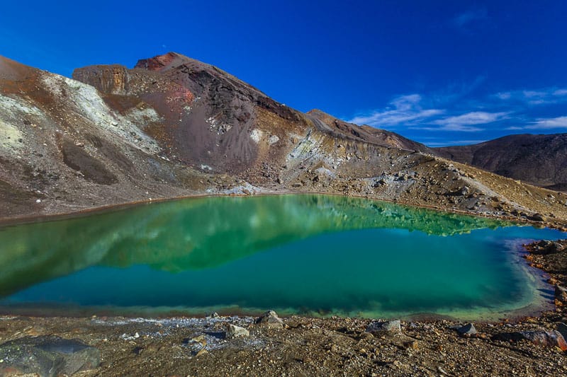
The Emerald Lakes were by far the most impressive thing we saw on the hike.
The shades of green, yellow, red and blue that give the lakes their impressive color are from the minerals derived from the surrounding rocks. Even though the smell of sulfur here was pretty bad I felt like I couldn’t take my eyes off these beautiful creations.
Blue Lake
I thought it was going to be all downhill from the Red Crater but I was wrong. The track pitched up again as we made our way to Blue Lake. This lake is considered “Tapu” or sacred. Nobody may touch or drink from it.
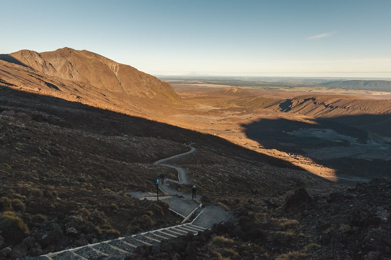
After the Blue Lake most of the impressive scenes are behind you so don’t forget to turn around and take a look. This trek is meant to be appreciated from all angles.
Ketetahi Car Park and Shelter
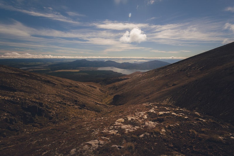
As the hike starts to come to an end the scenery never lets up. Making your way down to the car park we continued to steal looks back at the track we had just done.
We could see steam coming from the Te Maari Crater and were reminded that this is still an active volcano. In fact, you will see many signs on this part of the track reminding you of that. The vegetation changes as you get lower and gets even boggy so remember not to leave the trail.
The End of the Hike
The final 30 minuted of the hike is pretty uneventful and you will be tired. There is an optional short track that branches off the main one that takes you down to a waterfall if you still have the energy. We actually made haste here as we were quite tired and wanted to get back to the parking lot for the shuttle.
There is no doubt in our minds that the Tongariro Crossing was one of the best day hikes we have ever done.
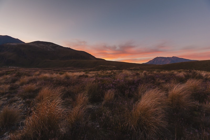
The weather was fantastic, the views unforgettable and the adventure-meter was high. The Tongariro Alpine Crossing was definitely the highlight of the North Island of New Zealand for us.
Helpful Articles to Plan Your New Zealand Vacation
- Caving: Glowworm Caves, New Zealand – a Dazzling Display of Light
- Things to do: 46 Top Things To Do In New Zealand
- Wanaka: A Local’s Guide to The Best Things to do in Wanaka, New Zealand
- Bungy Jumping: Where to Bungy Jump in New Zealand
- Rafting: Whitewater Rafting Class 5 Rapids in New Zealand
- Campervan Travel: Explore New Zealand by Campervan
- Christchurch: 21 Things to Do in Christchurch
- Wellington: The Best Places To Visit In Wellington, New Zealand
- Queenstown: Things to do in Queenstown
Tongariro Crossing Facts:
The Tongariro Crossing is a 19.4km point to point hike.
Most people complete the track in 6-8 hours. It depends solely on your fitness level.
I would classify the hike as strenuous. The elevation gain is 760m and there are some very steep sections.
The most common starting point is at the Mangatepopo car park which is located 16km from National Park Village on the North Island of New Zealand.

Mount Doom! New Zealand has been on our bucket list for a looooong time. I’m hopeful we’ll be able to get out there in 2021, and am a bit envious about how the country’s been handling current circumstances. Saving this for later!
Nice! I’ve hiked that trail in 1998, it’s so impressive up there!
It is beautiful isn’t it. The weather can change so quickly too, we could go back again and again and probably have a different experience each time.
Stunning place indeed!! Those emerald lakes are such deep rich green in color!! Magnificent landscapes.
Have a wonderful week 🙂
That water and sky- unreal looking! We have to get ourselves to NZ!
Your photos are inspiring! I’m going down myself to check it out. Are there any accomodations around the mountains?
I want to go – I’ve seen other blog posts on this hike but your photos are so fabulous that I want to do that hike now.
I know I’m the non-hiker but I actually did Tongariro. I was about 45 minutes from the top and it started raining and then hailing. I’m pretty sure I cried but I’m not completely sure because my face was soaking wet from the rain.
Excellent set of pics for perhaps the best one day walk there is – great memories!
Stunning, stunning, stunning! Unfortunately, my upcoming trip to NZ is only going to be 2 weeks long, and focused on the South Island. So it looks like I will once AGAIN be missing out on this hike! Next time, next time…
Enjoy the South Island Amanda, When are you going to New Zealand? There are other great hikes there too so you won’t be missing out. Have a blast.
Stunning photographs. I love the sky in the last photo with the final trail. Just brilliant!
Hey Pete, yes the sky was incredible wasn’t it. I found the skies in New Zealand to be very dramatic. The weather changes so quickly that the clouds are always offering up interesting images against the deep NZ sky. I have never seen blues in the sky anywhere else like I did in New Zealand.
Wow – That green lake is unworldly! Amazing shots!
What incredible pictures!!
The sight is really awe-inspiring. How I wish I can visit the place. But for now, am contented going over these pictures. Really amazing!
wow , these are amazing shots. Especially the small clear looking lake. Great photo opportunities.
i’m in love…
Beautiful pics. Mt. Doom is so much prettier in person.
Stunning place. This is on the top of my list of the best treks I’ve ever done. The lakes are jaw-dropping!